Tag: NASA

  • Taters the cat: Why Nasa beamed a cat video 19 million miles into deep space – Times of India

    Taters the cat: Why Nasa beamed a cat video 19 million miles into deep space – Times of India


    NEW DELHI: In an innovative move, Nasa beamed a cat video a staggering 19 million miles away, showcasing an unprecedented feat in the realm of deep-space communication. This unique endeavor was part of a larger test for the Deep Space Network (DSN), a global network of massive radio antennas that provides communication links between Earth and the spacecraft navigating the void beyond our immediate celestial neighborhood.
    The DSN’s primary role has always been to maintain communication with missions far beyond Earth, ensuring that vast distances do not hinder humanity’s exploration of space. As missions travel farther into the cosmos, the challenge of maintaining robust, uninterrupted communication channels becomes increasingly complex. It’s here, amidst the daunting silence of deep space, that the cat video plays an unexpected, yet pivotal role.
    The video was not just any internet meme; it served as a test object for a new communication paradigm known as Delay/Disruption Tolerant Networking (DTN). Traditional internet protocols are ill-equipped to handle the immense distances and variable conditions of space travel. Signal delays can stretch to minutes or even hours, and connections can be disrupted by planetary bodies or solar events. DTN addresses these challenges by creating a more resilient communication framework, one that can store data during disruptions and forward it once the connection is re-established.
    The feline star: Taters the cat
    The star of this cosmic transmission is none other than an orange tabby cat named Taters. A mere 15-second video clip of Taters was selected for the experiment. But why a cat video? It serves as a test case, pushing the boundaries of what’s achievable in deep space communication. By beaming Taters’ antics across 19 million miles, Nasa assessed the feasibility of transmitting data, imagery, and videos over vast cosmic distances.
    By sending a cat video, which is a culturally ubiquitous and data-intensive file, Nasa was able to rigorously test the DTN’s capabilities. The selection of a cat video also symbolizes the blend of human culture with cutting-edge technology, grounding the celestial endeavor in the familiar and everyday. This serves to demystify space technology, making it more relatable to the general public and highlighting Nasa’s innovative approach to problem-solving.
    The successful transmission of the cat video to a spacecraft located 19 million miles away is a testament to the advancements in space communication technology. It marks a significant step forward in ensuring that, as humans venture further into space, they will not lose the vital lifeline that connects them back to Earth. This achievement not only paves the way for more reliable communication in future deep-space missions but also opens up new possibilities for sending and receiving complex data across vast distances.
    So, will astronauts one day video call from Mars?
    The answer lies in the ongoing refinement of DSOC and its integration into future missions. As humans venture farther into space, our need for seamless communication grows. Whether it’s sharing scientific discoveries, capturing breathtaking vistas, or simply sending a cosmic “hello,” DSOC holds the promise of transforming how we connect across the cosmos.


    Source link

  • Europa clipper mission set to launch in October; ‘message in bottle’ in 103 languages – Times of India

    Europa clipper mission set to launch in October; ‘message in bottle’ in 103 languages – Times of India


    NEW DELHI: NASA is set to conduct its first mission for a detailed science investigation of Jupiter’s moon Europa in October. Scientists predict a vast salty ocean beneath its icy crust, possibly holding the necessary elements to sustain life.
    Europa Clipper’s main science goal is to determine whether there are places below the surface of Jupiter’s icy moon, Europa, that could support life.
    After traveling 1.6 billion miles (2.6 billion kilometers), Europa Clipper will conduct 49 close flybys of Europa, examining its subsurface ocean, icy crust, atmosphere, and space surroundings.
    In a campaign named “Message in a Bottle,” people were invited to add their names to an original poem dedicated to NASA’s Europa Clipper mission before the spacecraft launch. The poem and the names will be like a message in a bottle, traveling billions of miles as the mission investigates whether the ocean thought to lie beneath Europa’s icy crust could support life.
    The spacecraft’s scientific instruments are stored in a protective metal vault, safeguarding them from Jupiter’s intense radiation. Recently, NASA disclosed information regarding a triangular metal panel serving as both a seal for the vault and a commemorative plate.
    The message plate in Europa’s Clipper
    The plate, crafted from tantalum and measuring around 7 by 11 inches (18 by 28 centimeters), features graphics and text on both sides. Its surface accommodates five distinct elements: a poem, a scientist’s portrait, the outline of a bottle, and two messages related to SETI (Search for Extraterrestrial Intelligence). These messages include the renowned Drake Equation and “water hole” emissions, which denote a specific range of radio frequencies considered optimal for interstellar communication due to minimal background noise.
    The exterior portion of the plate displays graphics that emphasize humanity’s connection to Europa, featuring recordings of the word “water” spoken in 103 languages.
    Audio recordings were transformed into visual waveforms, which were then etched onto the plate. A symbol for “water” in American Sign Language appears at the center.
    “The message of connection through water, essential for all forms of life as we know it, perfectly illustrates Earth’s tie to this mysterious ocean world we are setting out to explore,” said Lori Glaze, director of the Planetary Science Division at NASA Headquarters in Washington, in a NASA statement.
    Three main Objectives of Mission Europa
    The mission’s three main science objectives are to understand the nature of the ice shell and the ocean beneath it, along with the moon’s composition and geology. The mission’s detailed exploration of Europa will help scientists better understand the astrobiological potential for habitable worlds beyond our planet.
    Europa Clipper will orbit Jupiter and make nearly 50 flybys of Europa at closest-approach altitudes as low as 16 miles (25 kilometers) above the surface, soaring over a different location during each flyby to scan nearly the entire moon.


    Source link

  • Nasa captures stunning ‘Necklace Nebula,’ located 15,000 light-years away – Times of India

    Nasa captures stunning ‘Necklace Nebula,’ located 15,000 light-years away – Times of India


    NEW DELHI: Nasa recently showcased ‘cosmic jewelry,’ a captivating celestial sight known as Necklace Nebula, captured by the Hubble Space Telescope. This mesmerising phenomenon, located 15,000 light-years away from Earth, was shared on Nasa’s social media, offering a glimpse of the vast wonders of space.
    NASA said that the Necklace Nebula, a stunning cosmic formation, was born from the interaction between two aging Sun-like stars.
    In a unique celestial dance, one star expanded and engulfed its smaller partner, which continued orbiting within.
    This caused the giant star to spin rapidly, shedding debris into space that formed the distinctive Necklace Nebula.
    The nebula features bright ‘diamonds’ of gas clustered around a glowing green region, resembling a necklace in space. Shared on Instagram, the mesmerizing image garnered over 55,000 likes and sparked admiration from viewers.
    The comments on these captivating glimpses, ranged from ‘absolutely beautiful’ to whimsical musings like ‘a cosmic giant lost her bracelet.’
    Social media users expressed awe, with one describing it as ‘stunning’ and another likening it to science fiction. The image, set against a backdrop of dark space speckled with stars and red gas, mesmerised viewers with its ethereal beauty and cosmic allure.
    (With agency inputs)


    Source link

  • Oldest ‘dead’ galaxy spotted by Nasa’s James Webb telescope – Times of India

    Oldest ‘dead’ galaxy spotted by Nasa’s James Webb telescope – Times of India


    NEW DELHI: The James Webb Space telescope detected a “dead” galaxy that ceased star formation when the universe was only 5% of its current age. The star formation ended approximately 13.1 billion years ago in the galaxy observed, just 700 million years after the Big Bang.
    This discovery by Webb telescope, operational since 2022, marks the earliest-known instance of a “dead” galaxy, surpassing previous findings by about 500 million years.
    Astrophysicist Tobias Looser from the Kavli Institute for Cosmology at the University of Cambridge, lead author of the study published in Nature, likened the galaxy to the late Hollywood actor James Dean, noting its fast-paced star formation followed by a sudden halt.
    “The galaxy appeared to have undergone rapid star formation before abruptly ceasing,” said Looser. “During the universe’s early stages, abundant gas fueled galaxy formation, making this discovery particularly intriguing.”
    This galaxy, estimated to contain between 100 million and one billion stars, is comparable in size to the Small Magellanic Cloud dwarf galaxy near the Milky Way. However, unlike the Small Magellanic Cloud, which continues to form new stars, this galaxy has entered a state of dormancy.
    “After star formation ends, existing stars expire without replacement,” explained Kavli Institute astrophysicist Francesco D’Eugenio, a co-author of the study. “The galaxy’s color shifts from blue to yellow to red as it loses its most massive stars first.”
    The researchers determined that the galaxy experienced a brief burst of star formation lasting between 30 to 90 million years before abruptly halting. They are currently investigating potential causes for this sudden cessation, including the influence of a supermassive black hole at the galaxy’s center or energy feedback from newly formed stars.
    “Alternatively, star formation may have ceased due to a depletion of gas, either from rapid consumption or a lack of replenishment,” added Looser.
    Nasa‘s Webb telescope, with its enhanced capability to observe distant objects, has provided astronomers with unprecedented views of the early universe. In this study, researchers observed the dead galaxy at a single moment in time, leaving open the possibility that it may have resumed star formation later.
    (With Reuters inputs)


    Source link

  • Alarming Nasa images show US east coast cities sinking at rapid pace – Times of India

    Alarming Nasa images show US east coast cities sinking at rapid pace – Times of India


    Major cities along the US East Coast are sinking at an alarming rate, with some areas sinking over 2 inches per year, according to new Nasa satellite data and analysis. This sinking, known as subsidence, has already made certain areas more vulnerable to flooding from storms and sea level rise caused by climate changes.
    Nasa’s satellite imagery and data, interpreted by scientists at Virginia Tech’s Earth Observation and Innovation Lab, demonstrate that various East Coast regions, including major cities like New York, Baltimore, and Norfolk, are subsiding annually by 1 to 2 millimeters from 2007 to 2020.
    Leonard Ohenhen, a Virginia Tech PhD student and one of the authors of the study, explained, “Our major findings show that between 2,000 to 74,000 square kilometers of land area, home to 1.2 to 14 million people and 476,000 to 6.3 million properties, are sinking at a rate of 1 to 2 millimeters per year.” This land subsidence poses a heightened risk of flooding and other coastal hazards, particularly when combined with the effects of global sea level rise.
    The subsidence map from Nasa illustrates areas of the East Coast that have been sinking or rising between 2007 and 2020, showcasing the widespread nature of the issue. The study also suggests that the mid-Atlantic coast is experiencing more significant subsidence than the northeastern coast, largely due to the historical weight of the Laurentide ice sheet.
    In South Carolina, Charleston is identified as one of the fastest sinking cities, with a rate of approximately 4 millimeters per year, exacerbating the city’s vulnerability to rising sea levels and leading to considerations for an 8-mile seawall to mitigate flooding and storm surges.
    The phenomenon known as glacial isostatic adjustment, where the land shifts similar to the movements of a seesaw, is believed to be a primary cause for the coastal sinking observed. In areas of Maryland and Virginia, the extraction of groundwater is also contributing to this downward trend. Furthermore, in coastal regions of Georgia, South Carolina, and North Carolina, the construction of dams, which prevent the natural accumulation of sediment, is another factor causing the land to sink.
    Charleston, South Carolina stands out as one of the cities most affected by subsidence, descending approximately 4 mm annually. This issue, in conjunction with escalating sea levels, poses a significant threat to the city, which is predominantly situated less than 10 feet above the current sea level.
    “It definitely will exacerbate the vulnerability of sea level rise in most coastal communities. Most communities will face the impacts of sea level rise sooner, due to the compounding effects of the sinking land and the sea level rise,” Ohenhen said.
    The research, aiming to extend to the Gulf Coast and eventually global coastlines, hopes to inform and assist urban planning to counteract these subsidence effects.


    Source link

  • Nasa’s ice-hunting VIPER Moon rover prepares for launch – Times of India

    Nasa’s ice-hunting VIPER Moon rover prepares for launch – Times of India


    NEW DELHI: Nasa‘s upcoming lunar mission, the VIPER (Volatiles Investigating Polar Exploration Rover), has taken a significant step forward as it prepares to head to the Moon later this year. VIPER project manager Dan Andrews recently announced, “All of VIPERs flight instruments are installed, and the rover is more than 80% built!” He described this progress as a major achievement, reflecting the hard work of the dedicated VIPER team, who are eager to see their efforts come to fruition.
    The rover’s mission is to explore the lunar south pole, searching for water ice and other resources.This exploration is crucial for supporting Nasa’s Artemis astronauts, including the first woman and the first person of color scheduled to walk on the moon in the Artemis 3 mission, targeted for 2026. Over a 100-day period, VIPER will traverse the lunar south pole region, creating detailed maps to locate water ice and assess the feasibility of resource extraction.
    VIPER is set to become the first resource mapping mission on another celestial body, significantly contributing to the goal of establishing a long-term human presence on the moon. Unlike previous missions, which collected data from lunar orbit, VIPER will examine the lunar surface directly, using advanced scientific instruments and a 1-meter drill to probe the soil at various depths.
    The rover will face the extreme conditions of the moon, including the intense cold of permanently shadowed regions and challenging terrain. The VIPER team is conducting thorough tests on the rover’s systems, including “channelization” tests to ensure all components, such as cable harnesses and connectors, are functioning correctly. Andrews emphasized the importance of this “test as we go” approach to mitigate risks and resolve any issues before the rover becomes inaccessible on the lunar surface.
    The VIPER team remains optimistic as they continue the rigorous testing and assembly process, with Andrews rallying, “Go VIPER!”


    Source link

  • Odysseus farewell: US Moon lander captures Earth’s ‘crescent’ in parting shot – Times of India

    Odysseus farewell: US Moon lander captures Earth’s ‘crescent’ in parting shot – Times of India


    NEW DELHI: The first US spacecraft to land on the Moon since 1972, Odysseus, entered a dormant state as the lunar night began. While the mission marked the first private company‘s moon landing, Intuitive Machines SEO shared with reporters the intention to “wake it up” in around three weeks when sunlight returns.
    Intuitive Machines’ Odysseus outlasted expectations despite landing on its side, facing issues with solar power and communication.
    The end came as flight controllers received Odysseus’ last photo and instructed its computer and power system to standby. This paves the way for the lander to potentially wake up in another two to three weeks, provided it weathers the harsh lunar night. Intuitive Machines spokesman Josh Marshall said these final steps drained the lander’s batteries and put Odysseus “down for a long nap.”
    However, prior to Odysseus’ moon lander entering the two-week lunar night, it sent a final transmission featuring the cratered lunar surface and a distant shadowed Earth crescent.
    “Before its power was depleted, Odysseus completed a fitting farewell transmission,” Intuitive Machines tweeted on X (formerly Twitter). They added, “Received today, this image from February 22nd showcases the crescent Earth in the backdrop, a subtle reminder of humanity’s presence in the universe. Goodnight, Odie. We hope to hear from you again.”
    Before losing power, Odysseus transmitted what Intuitive Machines described as a “fitting farewell message.” Captured right before landing, the image displays the lander’s underside on the moon’s pockmarked surface, with a small crescent Earth and Sun in the background.
    Odysseus, funded $118 million by Nasa to carry six experiments, marks the first company in Nasa’s commercial lunar delivery program. Unfortunately, it failed to reach the moon, as its lander crashed back to Earth in January.

    Seen as precursors by Nasa, these private landers aim to pave the way for upcoming astronaut missions in the next few years. The last US moon landing before Odysseus was by Apollo 17‘s Gene Cernan and Harrison Schmitt in 1972.
    (With agency inputs)


    Source link

  • Nasa’s TIMED satellite narrowly avoids collision with defunct Russian satellite – Times of India

    Nasa’s TIMED satellite narrowly avoids collision with defunct Russian satellite – Times of India


    NEW DELHI: An active Nasa spacecraft narrowly avoided a collision with an inactive Russian satellite in low Earth orbit.
    The close encounter between Nasa’s Thermosphere Ionosphere Mesosphere Energetics and Dynamics (TIMED) mission spacecraft and the Russian Cosmos 2221 satellite was predicted to occur at around 1:30am EST on February 28, at an altitude of about 373 miles (600 kilometers), according to a Nasa statement released just an hour before the event.
    The collision of these non-maneuverable satellites could have resulted in significant debris generation, endangering not only Nasa’s satellite, which studies the sun’s effects on Earth’s atmosphere, but also initiating a potentially disastrous chain reaction with other orbiting objects.
    “A collision could result in significant debris generation,” said Nasa and the Department of Defense representatives.
    This potential chain reaction of satellite debris in low Earth orbit, known as the Kessler syndrome, could be catastrophic and has been a growing concern among scientists due to the increasing amount of satellites and space debris. The Department of Defense currently tracks the 30,000 largest pieces of debris, but countless smaller fragments remain untracked and pose risks to satellites and the International Space Station.
    Efforts to address the space junk problem include Australian scientists proposing a method to remove smaller debris using a laser and the European Space Agency (ESA) planning to launch a robot in 2025 to collect space junk. ESA’s director general, Jan Wörner, has advocated for new regulations requiring entities that launch satellites to clean up their space debris.
    How space debris impacts satellite operations?
    Collision risk: The most direct impact is the risk of collisions with operational satellites. Even small pieces of debris, traveling at high speeds in orbit, can cause catastrophic damage to satellites, leading to loss of functionality or complete destruction.
    Maneuvering and fuel consumption: To avoid potential collisions, satellites often have to perform avoidance maneuvers, which can consume valuable fuel, shorten their operational lifespans, and disrupt normal operations and data collection.
    Design and cost: The threat of debris necessitates more robust satellite designs to withstand impacts, leading to increased costs in manufacturing, testing, and launching satellites.
    Orbital slots: Space debris can clutter popular and useful orbital paths, making them less accessible or increasing the risk for satellites operating within those paths.
    Long-term sustainability: Increasing amounts of space debris could lead to the Kessler Syndrome, a scenario where the density of objects in low Earth orbit is high enough that collisions between objects could cause a cascade of collisions. This would exacerbate the debris problem and could render some orbital regions unusable for generations.
    Communication interference: Although less common than physical impacts, debris can also interfere with the signals to and from satellites, affecting data transmission and operational control.
    Insurance and liability: The increased risk from space debris can lead to higher insurance costs for satellite operations and complex liability issues in the case of collisions involving active satellites.


    Source link

  • Commercial moon lander brakes into orbit, setting stage for historic landing attempt Thursday

    Commercial moon lander brakes into orbit, setting stage for historic landing attempt Thursday


    The Odysseus lunar lander fired its main engine for six minutes and 48 seconds Wednesday, putting the spacecraft into a 57-mile-high orbit around the moon and setting the stage for a landing try Thursday, the first for a U.S. spacecraft in more than 50 years.

    “Odysseus is now closer to the moon than the end-to-end distance driving across Space City, Houston,” spacecraft builder Intuitive Machines said on its web page. “Over the next day, while the lander remains in lunar orbit, flight controllers will analyze the complete flight data and transmit imagery of the moon.

    “Odysseus continues to be in excellent health,” the company added.

    022124-in-orbit.jpg
    A shot from a camera mounted on the Odysseus lander shows the spacecraft passing over the nearside of the moon.

    Intuitive Machines


    If all goes well, Odysseus will begin its descent to the surface Thursday afternoon, touching down near a crater known as Malapert A, 186 miles from the moon’s south pole, at 5:30 p.m. EST.

    “You know, of all the missions mounted to the moon in the history of mankind, there’s only been a 40 percent success rate,” Steve Altemus, a former space shuttle engineer and co-founder of Intuitive Machines, told CBS News in an interview last year. “We believe we can do better than that. And so, I put our odds at 75 percent success.”

    The odds are presumably better than that now, given the main engine’s actual performance in space.

    The commercially-developed lander successfully test fired the engine last Friday, one day after its launch atop a SpaceX Falcon 9 rocket. The 21-second “commissioning burn” verified the engine, the first methane-oxygen propulsion system used in deep space, worked as designed.

    022124-nova-control.jpg
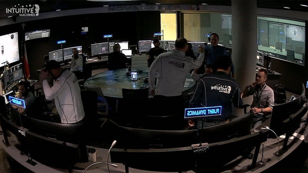
    The Intuitive Machines mission control center in Houston.

    Intuitive Machines


    Two trajectory correction maneuvers then were carried out to fine tune Odysseus’ path to the moon, putting the spacecraft on such a precise course that a third planned adjustment was not needed. That set the stage for Wednesday’s lunar orbit insertion, or LOI, burn on the far side of the moon.

    The make-or-break maneuver slowed the spacecraft, nicknamed “Odie,” by 1,789 mph to put the lander in the planned circular orbit.

    Flight controllers at Intuitive Machines’s Nova Control Center in Houston plan to work through a series of health checks, data reviews and rehearsals to make sure Odysseus is ready for its historic descent to the surface Thursday in what would be the first for a privately-built non-government spacecraft.

    The main engine will once again play a critical role, dropping Odysseus out of orbit and throttling down as required to ensure a gentle touchdown at a vertical velocity of about 2.2 mph.

    No realtime photos or video are expected during the descent, but flight controllers should be able to confirm touchdown within about 15 seconds of the actual landing. The first imagery from the moon is expected a half hour later.

    lander-artist1.jpg
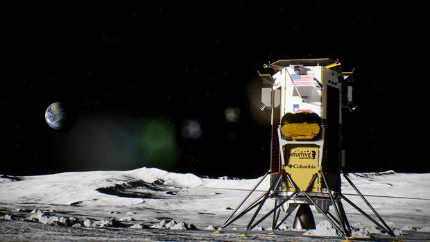
    An artist’s impression of the Odysseus lander on the surface of the moon.

    Intuitive Machines


    The spacecraft is carrying six NASA payloads designed to study the lunar environment and test new technology along with six provided by commercial customers. Those range from miniature moon sculptures by artist Jeff Koons to insulation blankets provided by Columbia Sportswear and a deployable student-built camera system.

    Only the United States, Russia, China, India and Japan have successfully soft landed on the surface of the moon. Three privately funded moon landers were launched between 2019 and this past January, one from an Israeli nonprofit, one from a Japanese company and most recently, Pittsburg-based Astrobotic’s Peregrine. All three failed.

    Peregrine and Odysseus were both funded in part by NASA’s Commercial Lunar Payload Services program, or CLPS (pronounced CLIPS), designed to encourage private industry to develop transportation capabilities that NASA can then use to transport payloads to the moon.

    The agency’s goal is to help kickstart development of new technologies and to collect data that will be needed by Artemis astronauts planning to land near the moon’s south pole later this decade.


    Source link

  • It’s not just rising sea levels – the land major cities are built on is actually sinking, NASA images show

    It’s not just rising sea levels – the land major cities are built on is actually sinking, NASA images show


    Rising sea levels are threatening the East Coast of the U.S., but that’s not the only thing to worry about, according to NASA. Images shared by the space agency on Tuesday show the coast is actually sinking — including the land that holds major cities such as New York and Baltimore. 

    A NASA-funded team of scientists at Virginia Tech’s Earth Observation and Innovation Lab found the geographical problem is “happening rapidly enough to threaten infrastructure, farmland, and wetlands that tens of millions of people along the coast rely upon,” NASA said.

    Scientists looked at satellite data and GPS sensors to monitor the motion of the coast and found that infrastructure in major cities like New York, Baltimore and Norfolk, Virginia, is built on land that sank between the years of 2007 and 2020. The land subsided, or sank, by an average of 1 to 2 millimeters a year, but some counties in Delaware, Maryland, South Carolina and Georgia saw their land sink twice or three times that fast.

    Scientists looked at satellite data and GPS sensors to monitor the motion of the coast and found that infrastructure in major cities like is built on land that sank between the years 2007 and 2020.

    NASA


    The land in marshes sinks by more than 3 millimeters a year, the scientists found. Forests have also been displaced due to the intrusion of saltwater and the subsiding land.

    And wildlife is not the only thing being affected. Along the coast, at least 897,000 structures — including highways and airports — sit on land that is subsiding. 

    The findings, which followed another study from the Virginia Tech lab, were published in PNAS Nexus.

    The maps shared by NASA were created using data from satellites from the U.S., Japan and Europe. They show the Mid-Atlantic region is sinking more — caused by the Laurentide ice sheet, which started retreating 12,000 years ago, causing the region to sink downward. The sinking continues today and it inversely causes parts of the U.S. and Canada to rise. 

    One of the fastest-sinking cities is Charleston, where downtown is just 10 feet above sea level. The city sees subsidence of about 4 millimeters per year. About 800,000 people live in the city, and a portion of the sinking is caused by human activities like groundwater pumping, according to NASA. 

    To prevent tidal flooding, the city is considering an 8-mile seawall to protect from storm surges. 

    screenshot-2024-02-21-at-11-04-44-am.png
    Charleston is suffering the worst subsidence, sinking about 4 millimeters each year.

    NASA


    Leonard Ohenhen, a geophysicist at Virginia Tech, called the issue of subsidence “pernicious” and “overlooked” compared to rising sea levels. But it’s still a major problem and people living along the coast could see more damage to their homes, saltwater infiltrating farms and fresh water supplies, and other challenges. 

    Subsidence, however, is a problem that can be slowed locally, said Manoochehr Shirzaei, a co-author on both studies and director of the Virginia Tech lab. Groundwater extraction as well as dams and other other infrastructure can also cause subsidence. 

    The lab will next use these research techniques on the Gulf Coast, with a goal of mapping all of the world’s coastlines, Shirzaei said. 


    Source link